Kategorie-Archiv: NV.Blog_Startseite_ENG_EU

NV.Blog_Startseite_ENG_EU

Preparations for the 2021 season are underway!

We are heading back towards the start of the season and all preparations are in full swing.
Despite the changed conditions, which have also been with us for months now, we are working to the same quality and high standards that you have come to expect from us and are updating our nautical chart sets as usual.

Again there are thousands of changes this season such as new marinas, relocated buoys, changed restricted areas and altered sandbanks and fairways.

We expect the updated charts for the Baltic Sea at the end of February, the new chart sets for the German North Sea and the Netherlands will be released at the end of March.
The French Atlantic coast (FR 1 to FR 7) will also be completely updated this year.

In addition to nautical charts, we are also continuously improving our NV Charts App, always taking into account the feedback and wishes of our customers wherever possible. So you can expect some optimisations and highlights for the year 2021.

We hope that the season – both for you and for us – can start as usual and we are already happy to take your pre-orders.

Stay healthy and look forward to exciting days on the water!

Your NV Charts Team

PS: Discover ports and anchorages for the 2021 season on SeaMe.com

Our App got tested by Digital Yacht: Compatibility confirmed

Digital Yacht – producer of next generation navigation, communication and entertainment systems – tested our App and published a nice article about the connection between the App, their AIS products and GPS data.
We don’t want to withhold the article from you and hope you enjoy reading it.

NV Charts & Digital Yacht AIS

„For decades, NV Charts have been creating nautical charts for the Baltic Sea, North Sea, Kattegat, Skagerak and the Norwegian south coast.  Chart coverage now extends to the UK, European Atlantic Coast, E Coast USA, Caribbean and Mediterranean.  With a keen eye on detail and precise local knowledge, every nautical chart is designed from the best available data. In many cases, their own detailed survey data supplements official hydrographic office charts.  NV Charts are also easy to read have have a nice colour palette and font/symbol schema.  Their charts are available in paper and digital format – and if you purchase a paper chart, it comes with a free app download too.  That’s great – traditional navigation meets the iPad!

The electronic version is now compatible with Digital Yacht AIS products and NMEA to wireless interfaces.  This means the boat’s AIS, instrument and GPS data can be overlaid onto the detailed charts turning your device (iPad or tablet) into a full function electronic chart system with routing, real time tracking and AIS overlays.  We took an iPad for a test with NV and the Digital Yacht AIT3000 and iAISTX Class B transponder.  You’ll see in the screen shot below the bright, easy to use colour scheme and icons for navigation marks.  Your current position from the boat’s GPS (which is much better than the battery thirsty internal GPS on some tablets) shows as a bold, red triangle with a heading vector.  Using the boat’s system means you don’t need an expensive GPS/Cellular enabled iPad and of course, no connection to the internet is required.

Just enable AIS and targets display automatically.  You’ll see the target just to the east of South Haven Point with a heading predictor showing a potential collision point.  Click on the target and more information is displayed in the data window – also calculating CPA (closest point of approach) and TCPA (time to CPA), range and bearing.

Charts can be configured for head up and north up presentation and waypoints and routes can be created in seconds.  There’s also a neat logbook function which can have pictures attached.  The screen shot below also shows targets with name data attached – great to initiate a VHF call to a potential collision target or boating buddy

This is all good stuff – and a real reason to use an iPad for all your boats navigation tasks.  Not only do Digital Yacht wireless nav solutions offer great value for money but you can now have a choice of multiple apps with multiple chart types turning your iPad into a true multi chart system.  For UK waters, iPad apps now offer compatability with C-Map, UKHO/Admiralty, Navionics, S57 Vector ECDIS style, Imray and now NV.  Easy to use, sophisticated and low costs apps for next generation navigation.“


Click here for further information of Digital Yacht.

The new App Update 2020 is here!

Ahoy dear water sports enthusiasts!

Gemeinsam macht Navigation an Bord noch mehr Spaß!

Together, navigation on board is even more fun!
For the boating season 2020 we have again provided a large update for the NV Charts App and a fantastic highlight is the possibility to become part of the charting community yourself. You can now add your favourite harbours and anchorages with pictures and share them with the community. Other users can react directly with comments. The continuously edited content can be downloaded directly to be available offline. This makes the NV Charts app uniquely well integrated navigation and planing on board.

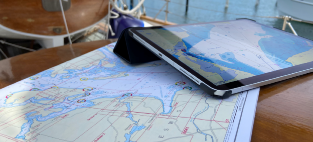
Enjoy the NV Charts Web App online in your browser now for planning your next trip or exploring a new area.

In order to make all information easily accessible, we have improved the search function: You can explore the surroundings and search directly for place names as well as anchorages, harbours, ramps, waypoints, cranes, petrol stations, or tide stations. In addition, an auto-routing function has been integrated, which allows you to navigate directly to your destination.

Have great fun on the water and especially while discovering the new app features!
Your NV Team


Download the NV Charts App for the appropriate operating system::


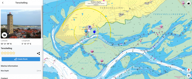
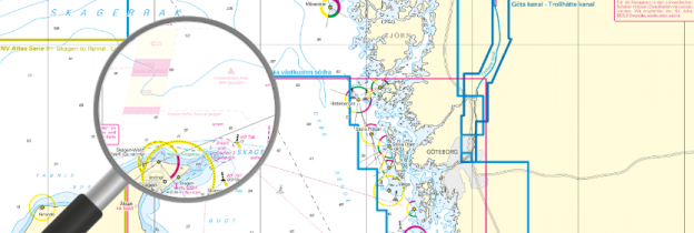
Points of Interest (POI)


POI, using Mönkeberg as an example


Auto-Routing*


The new auto-routing

The auto-routing allows en even easier route planning, taking the ship’s data into account. Destinations can be added or individual sections can be routed manually.
In addition, waypoints can be easily transferred to the paper chart (via the coordinates) or vice versa. This is not only for safety reasons and will of course practice all your practical navigation tallents, it is also a great opportunity to check the route in detail and discuss it with everyone on board.

*Auto-routing is currently available for our series of the Netherlands, the German North Sea and the Baltic Sea. Other areas will follow soon.


More highlights


✔ In-App purchases of digital charts
✔ Vector charts for the Baltic Sea
✔ Real-time currents in the North and Baltic Sea
✔ regular updates
✔ Tide Forecast and Online Weather
✔ NMEA wind and echo sounder support
✔ AIS connection incl. AIS SART MOB support
✔ Synchronization with other devices + file export
✔ the current charts 2020 already show the planned new traffic separation areas in the Baltic Sea

System requirements for the new app version:
## IOS Version 13
## Android version 7.0 or higher
## Windows 10, 8
## Mac OSX 10.13 10.14 10.15 (current version)

With the AIS function in the NV Charts App you can keep an eye on AIS signals in real-time. You can connect a Wlan AIS receiver to the NV Charts and the app display AIS Class A and B signals and navigation aids (ATON), as well as MOB AIS SART transponder distress transmitters, directly in the digital chart in real-time and the traffic situation can be assessed better.


Download the NV Charts App for the appropriate operating system:

Free online NV Charts Web App

Online and free NV Charts Web App for your trip planning

Enjoy the NV Charts App also as an online web viewer chart app simply in your browser free of charge for planning a cruise or exploring a new sea area and as an online harbour and marina guide. By registering with the free NV Charts Web App online nautical chart app, you can also easily synchronize all data to your mobile devices and start navigating on board directly. NV Charts Web App is the online version of the popular NV Charts App and is the ideal complement to use on your mobile devices online in your browser featuring the latest chart data and intuitive operation. All community layer information with ports, harbours, anchorages, navigation waring, photos, shops and places of interest are displayed directly online in the NV Charts App, and information can also be added by you or commented. You can share your favorite harbors and anchorages from the marine navigation app by simply clicking on a link and coordinate your trip planning with everyone on board. Together with the NV Charts community website Seame.com a detailed planning tool is available right here.

Continue to free
NV Charts Web App registration

We offer free shipping during Easter!

April – Ships are launched, final work is done and the season can begin. This is how we know spring in the nautic industry.

This year everything is different and we work under different conditions. Nevertheless, we are trying to look positively into the season 2020, which also marks our 40th anniversary.
Many of you have been with us for decades and in recent days we have received an incredible amount of positive feedback from our customers. We are very grateful for this and would like to give you something back:

During the entire Easter weekend you can order all of our nautical charts free of shipping costs from our online shop.

We have adapted very well to the changed working conditions and our office will remain manned for you. We are available as usual and can process and ship your orders regularly.

In times like these, solidarity is especially important and we wish to return to normal as soon as possible, just like you.

Until then we are looking forward to your orders, wish you a happy Easter and hope you stay safe!
Your NV Team

nv charts will continue to distribute nautical charts and nautical publications in the coming days, weeks, months.

Our business with the supply nautical charts and equipping ships, yachts and boats with important nautical publications will continue, and accordingly our shipping operations are also running smoothly.
Well prepared for the comming water sports season!
We have built up stock, updated on the online presenation, freshly printed charts are ready for delivery to customers and new products area available in our web presentation.

Remote Support – Telephone Advise – technical help for our customers

Should you occur issues with nautical charts, installation of navigation software or with the unlocking of digital products, our experts will help you along.

We have established a technical support team for the nv charts App and related products.
Our colleagues are available Monday – Friday from 9:00 am to 1:00 pm via +49 (0)4351 860 99 21 or you send us an e-mail.


Reliable shipping with DHL – express service on request possible with UPS

As usual we are delivering our parcels with DHL. Deutsche Post continues to work reliable and we have fast delivery times in Germany and all over Europe. The usual pick-up time in Eckernförde is 16:30hrs (local time), so if you can send us your order during the afternoon, we usually can send your charts the same evening.

New Kattegat traffic seperation schemes

From July 1st new traffic seperation shemes and relocated commercial shipping ways are in force in the Kattegat and off Skagen.

These developments are important for the small craft and leisure marine boaters as well, as TSS shall not be crossed other than in 90° angle to traffic direction, the respective inshore traffic zones are to be used and it is good seamannship to sail out of the commercial shipping lanes.
The new 2020 editions of the nv charts atlas have these alterations already included and added comments in the charts. The digital charts update automatically.

TSS Lilla Middelgrund - new 2020 New traffic seperation sheme TSS Lilla Middelgrund south west of Varberg (SWE) which helps the traffic along the newly established shipping lane „S“.
TSS Fladen neu im Kattegat 2020 New TSS Fladen between lighthouses Nidingen and Fladen which helps to guide commercial traffic away from the coast and along the newly established shipping lane „S“.
Vorsichtsgebiet Kummelbank Newly established precautinary area AT Kummel Bank, where the shipping lanes „S“ and „T“ meet. The route from Gothenburg to Læsø crosses here.
TSS Skagen neu im Kattegat und Skagerak Two newly established traffic seperation shemes TSS Skagen West and TSS Skagen East with related precautionary area between and inshore traffice zone towards mainland.
kein Bild Commercial shipping lane „S“ new established which runs from the Sound and close to the Swedish coast through the two tss Lilla Middelgrund and Fladen up to the precautinary area AT Kummel Bank.
kein Bild Relocated commercial shipping lane „T“.
Position der Anholt Knob Mittenfahrwassertonne New position of light buoy Anholt Knob, which relocates the shipping lane „T“ further away from the eastern tip of Anholt.

n the 2020 edition of the series 3 for the Kattegat, these changes and corresponding notes are already printed in text form. A correction of the edition in the middle of the season is not necessary. Please make sure that on board you always have the latest edition with you.

Digital charts always up-to-date with the nv charts App.

For the series 3 there is a monthly correction service which provides you with regular digital updates of the nautical charts for the current year of the edition. Use this convenient service and you can download the updated version of the charts.

Also the charts of series 9 (Danish West Coast and Limfjord) and series 5.2 (Swedish West Coast South) will receive an unscheduled update in electronic form for all customers who have registered their current charts in the app.

NV Charts is racing the Minitransat 2019 with Felix de Navacelle

Racing the Minitransat is an incredible adventure, but also very demanding in terms of
navigation… Only GPS coordinates and paper charts are allowed!

In my confined living space, surfing at +15 knots along the coast or across the ocean, I need to get a fast and clear sight of my position. nv charts became my real advantage, their well dimensioned book-like format allows me to store and deploy them fast and at ease in the roughest conditions.
Moreover, they combine general overviews and detailed zoom in the same document
which makes them very simple to interpret and manipulate.

Navigation just went from a certain apprehension to a real pleasure and interest.

Get your nv charts for the Atlantic here: https://eu.nvcharts.com/en/charts/atlantic-ocean


Find out more about Felix at: http://navasail.com/

NV Charts nominated for Dame Award

NV Charts’ new NV Atlas chart format has been nomintaed for the prestigious DAME Design Award, ‪#‎DameAward‬, the most prestigious international design competition for new marine equipment and accessories at the ‪#‎METS‬ Metstrade show this year in  Amsterdam. We thank you and the DAME Design Award Jury for liking our new NV Atlas chart format, a revolutionary new design approach that’s so handy and easy to use! Visit us in our #METS booth, Hall 4, Stand 133, and let us show it to you.  ‪#‎metstrade‬